
According to official forecasts, La Nia will most likely return for the winter.
The National Oceanic and Atmospheric Administration’s (NOAA) Climate Prediction Center reported on Thursday that La Nia conditions have emerged and are likely to persist from December through February, with an 87 percent likelihood.
La Nia (Spanish for “little girl”) is a climatic phenomenon that happens every few years in the Pacific Ocean and has an influence on weather all across the world.
Temperature and precipitation are likely to be affected in the United States, which might have ramifications for hurricanes, tornadoes, and droughts.
Forecasters remind out that this is the second consecutive La Nia winter, a typical occurrence known as a “double-dip.” From August 2020 to April 2021, the most current period was in effect. (For more on what has transpired subsequently, see below.)
Mike Halpert, deputy director of NOAA’s Climate Prediction Center, stated in a press release that “we scientists have been watching the possible formation of a La Nia since this summer, and it was a component in the above-normal hurricane season forecast, which we have seen unfold.” “During the winter, La Nia has an impact on weather across the country, and it will have an impact on our forthcoming temperature and precipitation forecasts.”
On October 21, the National Oceanic and Atmospheric Administration (NOAA) will announce its official winter forecast. Meanwhile, here’s a crash course on how La Nia works and what it means for different areas of the nation.
What exactly is La Niña?
La Nia, according to scientists, is not a storm that hits a certain place at a specific time. Instead, it’s a shift in global atmospheric circulation that has an impact on global weather.
Consider how a large construction project across town might alter traffic flow near your home, with people being rerouted, side roads carrying additional traffic, and typical exits and on-ramps closed, according to a NOAA webpage. “At different times of the day, different neighborhoods will be the most affected. The building project’s impacts would be felt through variations in usual patterns, but you wouldn’t anticipate the project to ‘strike’ your home.”
Let’s begin with a technical explanation: It’s part of the El Nio-Southern Oscillation (ENSO) cycle, which is characterized by contrasting warm and cool oceanic and atmospheric conditions in the Pacific.
On average, La Nia and its counterpart, El Nio, chill and warm vast portions of the tropical ocean every two to seven years. (There is also a “neutral” state, which we’ve been in since the previous La Nia ended.)
Forecasters can formally proclaim a La Nia event when sea surface temperatures fall below a specific threshold, are expected to stay below that threshold, and cause a notable atmospheric reaction, such as changes in winds, according to the NOAA (which has a helpful flowchart).
Here’s how that works.
“Trade winds travel west down the equator in typical circumstances in the Pacific Ocean, transporting warm water from South America to Asia. Cold water rises from the deep to replace the warm water, a process known as upwelling “NOAA describes the situation. “El Nio and La Nia are two opposing climatic trends that deviate from the norm.”
When the trade winds are stronger than usual because to La Nia, more warm water is pushed toward Asia. Meanwhile, cold water is rising to the surface off the west coast of the Americas due to increased upwelling. (The nutrient-rich water also attracts cold-water animals such as squid and salmon to the California coast.)
The jet stream moves northward due to cold seas, then weakens across the eastern Pacific.
So what does that actually feel like on the ground?
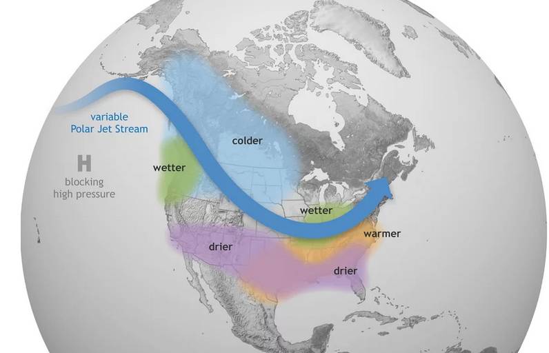
According to NOAA, La Nia has the greatest influence on North American rain, snow, and temperatures throughout the winter.
In general, La Nia winters are drier and warmer than average in the southern United States, and cooler and wetter in the northern United States and Canada.
More rain and snow may fall in the Pacific Northwest, sections of the Midwest, and the Tennessee and Ohio valleys than in an usual winter.
La Nia can also result in a more severe Atlantic hurricane season, as we’re witnessing this year.
While La Nia occurrences are linked to specific climatic trends, such as temperature and rainfall variations in different regions of the nation, forecasters emphasize that they are a question of “probability, not certainty.”
If you’re wondering if La Nia will have an impact on your house this winter, NOAA experts provide the following advice:
“Maybe. Probably. Most likely not. The response is contingent on a number of circumstances, including where you reside, the strength of the event, and other climatic trends that emerge and impact the seasonal outcome.”
What about weather events such as snow, flooding and tornadoes?
Although snowfall is difficult to forecast, scientists believe La Nia will bring more snow to the Northwest, northern Rockies, and Upper Midwest Great Lakes area. The Southwest, central-southern Plains, and mid-Atlantic will likely get less rain than typical.
In general, La Nia causes more storms in the Atlantic but fewer in the eastern and central Pacific (El Nio does the reverse). Those Atlantic hurricanes, according to NOAA, develop in the deep tropics from African easterly waves, making them more prone to become big hurricanes that may reach the Caribbean and the United States.
Tornadoes and which regions of the country are more likely to see them appear to be influenced by the position of the jet stream. The jet stream and severe weather are more likely to be farther north during La Nia winters.
La Nia could exacerbate California’s current drought, making the state’s wildfire season even more dangerous. According to Bloomberg, the majority of the state’s yearly water comes from rain and snow between November and April, which is also when La Nia is expected to move storm tracks north and away from the region that needs it.
While the southern United States may face protracted drought, the northern United States, particularly the Pacific Northwest, is anticipated to receive significant rainfall and flooding.
How long will it persist, and how frequently will it occur?
El Nio and La Nia episodes, according to the National Ocean Service, generally last nine to twelve months but can often span years.
Both tend to emerge in the spring, peak in intensity in the late fall or winter, and then go away in the spring or summer.
In other words, La Nia will have the greatest impact on the United States between January and March, although it may persist until early spring.
Why is it called that?
South American fisherman had long seen warmer-than-normal coastal Pacific Ocean waters and severe declines in fish harvest around Christmastime, according to the background. After baby Jesus, they named the phenomena El Nio, which means “small boy” in Spanish.
As a result, when scientists discovered the polar opposite of El Nio in the 1980s, they named it La Nia. (Of course, these days, terminology concerning gender identity and expression is much more complicated.)
What does this have to do with climate change?
Scientists aren’t sure how a warmer planet might influence the ENSO cycle just yet.
“But keep in mind that just because we don’t have high confidence in how ENSO could evolve in the future doesn’t imply it won’t,” NOAA wrote in a blog post in 2016. “It just means there’s more work for scientists to undertake.”
They are optimistic, however, that ENSO will continue to exist in the future. They also believe that global warming will have an impact on La Nia’s effects, particularly extreme weather occurrences.
Credit:NPR